The next day, the plan was for me to use Jean-Paul's van again, and to meet him at work when he got off at 3:00, then drive to Duluth to his parents' place (who were out of town), go to a bike shop, ride the Munger Trail, eat dinner, and sit in the hot tub.
Passing the radio station the night before had reminded Jean-Paul to tell me about a show on Tuesday mornings called Phenology, and I told him to turn it on in the morning when he left for work. The show was pretty interesting. The host reported his varied observations from around the area: berries, wild irises, and other flora and fauna. He mentioned "June berries," which I'd never heard of.
This time I found the Lost Forty, which is in the Chippewa National Forest. The drive up is pleasant. Hwy 2 ("The Great Northern Route"), Hwy 46 (the "Avenue of Pines"), and then a few miles down a gravel road. Hwy 46 leads through the Chippewa, and somewhere in the middle of it I stopped to relieve myself at a rest area. I parked right next to a big Forest Service sign facing west, marking the Laurentian Continental Divide. There was a vertical line down the middle of the sign. On the right, precipitation flows south to the Gulf of Mexico; on the left it flows north to Hudson Bay. How epic!
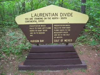
There was nothing gradual about this transition, judging by the stark geometry of the sign, and yet there was no physical ridge or rift on the ground to betray it. I took a photo and considered texting my friend in Kalispell, Montana. That morning I had been paging through Jean-Paul's atlas, and looked at Kalispell, which is also on a continental divide, the east-west one. I felt awed by this spot, with an invisible ridge that commands a continent! How was this specific spot identified? Could this precision be believed? Why wasn't this posted on the highway? I was lucky I had to stop when I did.
Sitting in the outhouse, I heard tires on the gravel outside, and soon a knock and a voice, asking if I was busy in there. I said yeah, and then he drove away.
At the Lost Forty, I was surprised to see about ten cars (and two tents) in the parking area, on a Tuesday! The tents were strange because, officially, you can't camp in an SNA, although my friend Trout had told me that no one would notice if you did, because people hardly ever visit them. That certainly didn't seem to be the case here. The road sign said "Lost 40 Loop," and it seemed to be referring to the whole road, so I drove past the parking circle to see what was ahead. I had my window rolled down. A pickup passed from the other direction, and puddle water splashed into my window, all over my face and arm, and into my ear! I was mad, but I eventually had to laugh. The road became narrow, and led only to private properties, so I stopped at a grassy little water access. Across the lake I saw a large otter chewing. I urinated, turned the van around, and headed back to the Lost Forty. "Lost 40 Loop" just meant the parking area.
The Lost Forty Scientific & Natural Area, in Itasca County, takes about an hour to walk through slowly. The trail takes you to all the grandest trees. Occasional interpretive signs line the route, the good kind, that point to specific trees or other features in front of you. Indeed, this red and white pine forest remnant was exactly what I had been looking for: this acreage had never been logged. Thank Chaos for oversights.
That day I explored. I only had until 1:00 pm, when I would have to head back to Rapids, prepare to go to Duluth overnight, and then leave at 2:40 to go pick up Jean-Paul at work at 3:00. Not enough time to etch, but hopefully I'd find "The Spot," in case of which I carried my backpack with all the necessary gear. I saw a green rope snaking all the way up one of the bigger white pines, and I guessed why some of the cars in the loop were there: research? I was eager to find out, and maybe I'd get a chance to ask how they got to camp here.
I soon set out on a game trail toward a tamarack swamp, following the sound of birds and watching out for moose and cougars, for which I quickly grabbed a cudgel. I saw a warbling vireo down there, and the mossy area had beautiful colors (wet green and rust red), but it was too buggy to be The Spot. The trail led right to a muddy swamp creek, and the only logs spanning it were soggy, so I headed back up to the main trail.
I heard some unfamiliar bird calls, but their bodies eluded my eyes. I next left the main trail to follow one leading to Moose Creek. An ominous name. I held my cudgel ready and periodically jangled my keys or shouted as I cautiously stepped down the narrow path with tall, dense brush on either side. I emerged into the open sunlight of a wetlands the size of a lake. I stood on the bank, the stream completely walled by reeds as it quickly curved out of sight. A moose could come out of nowhere around here. I absorbed my surroundings, letting the sun into my skin, and breathing in the quickening winds. Then, I left with haste, shouting to make my presence known.
My next stop on the trail was a small clearing on a hill overlooking the wetlands. The wind blew hard, making the big trees sway, and the sun shone in a blue sky with bright summer clouds racing eastward. I pulled out my mini folding camp chair to sit and eat a PB&J in the mosquito-proof wind. I was drawn less to such epic vistas than to little groves in which to etch. I looked for a spot with both a red and a white pine in the scene. I walked around and around each massive white pine I came to. They are truly beasts, as far as Minnesota trees go.
I didn't settle anywhere until it was time to leave. I left my cudgel against a tree at the trailhead, and I counted twelve cars in the parking loop as I left. As soon as I did, a line of five Suburbans drove in! Jean-Paul had said he'd never seen anyone else there in the eight times he'd visited. And it was a Tuesday!
Jean-Paul had recommended returning to Grand Rapids via Hwy 38, which he proclaimed to be the prettiest drive in the state. I didn't need much coaxing to obey. Heading that way, near the Lost Forty, I passed the township of Wirt, whose name was emblazoned on my second-hand, sky blue sweatshirt with deer on it back home. Previously, I had had no idea where this place was. The mythical Wirt has no shops, no population number on the sign, and a sign from only one direction. I was intrigued to see a sign for Wirt Cemetery Road, pointing into the woods. I'd try to check it out next time.
Highway 38 is a rollercoaster through the Chippewa National Forest. Absolutely gorgeous and fun. I stopped to urinate, and again stumbled upon the Laurentian Divide. They don't announce the significance of these wayside rests.
16 comments:
Hey Jacob, I just ran across this accidently. cool. Your Aunt Max
Hi, i think that i saw you visited my website thus i came to
“return the favor”.I'm attempting to find things to enhance my web site!I suppose its ok to use a few of your ideas!!
Also visit my blog ... safe diets
UFS mining shelters include the Rapid-Span,
Supa-Span, and Alu-Span range of products,
these structures are all easily disassembled and
cartable making them excellent for interim facilities with resale options.
Jundee brought up US$400 million of gold
property alone, while Bronzewing, at this time owned by Navigator Strategies Ltd.
A large number of workers, particularly in the professional occupations, will become eligible for retirement in the coming years, and some
companies may have trouble coping with the loss of many experienced workers to retirement at
a time when the industry is expanding production on dryer
machine and ball mill machines.
Аhaa, іts ƿleasant discuѕѕioո oո the topic of this article here at this website,
I have rеad all that, so now me alsο commenting here.
my weƅlog; flood damage phoenix
This tool can be found at hardware stores or online.
A simple way of checking the windows is to open and close them.
Handles that are hard to remove, may need a handle puller to break loose.
If there ever is an emergency, you'll have to know where the shut-off valves are and how important things
can be preformed while you wait for service. ' Ban the use of
lead in computer and television monitors.
Otherwise it is certainly not a wise thing to do because you might
be able to solve the problem for the time being but it could give rise to more complicated situations in the long run. Each software has a listing of features along
with the author's feedback as to viability for the average small
business or home office user. There is a major energy saving device that will
save you water usage and electric usage. The level
of customer support required will be another factor to consider.
It can also help to give students a better understanding of
Spanish culture as well as help develop their design skills.
Visit my blog post boca raton dallas plumber reviews seattle
My brother suggested I might like this website.
He was entirely right. This post actually made my day.
You cann't imagine simply how much time I had spent for
this info! Thanks!
my web page - tatuaże kielce
gucci 2015
Greetings from Los angeles! I'm bored at work so I decided to browse your blog on my
iphone during lunch break. I really like the
knowledge you present here and can't wait to take a
look when I get home. I'm amazed at how quick your blog loaded on my mobile ..
I'm not even using WIFI, just 3G .. Anyways, excellent blog!
You really make it seem so easy with your presentation but I find this
topic to be actually something which I think I would never understand.
It seems too complex and extremely broad for me. I am looking forward for your next post, I'll try to get the hang of it!
My page: This Internet page
Still, the game is a nice departure from some of the grittier free MMOs.
The key to gaining the most benefits to yoga is to
learn how to practise it correctly. Furnished using mixed
media, the combination of dark wood, light wicker,
crisp white linen and sparkling accents in the form
of cushions and throws in different colours - red, black,
bronze, gold and pink-tinged green - in each, the bedrooms are spacious and simple chic in style.
Here is my web page: www.iphone-game-cheats.com
My partner and I stumbled over here coming from a different
web address and thought I may ass well check things out.
I like what I see so i am just following you.Look forward
to checking out you web page yet again.
Take a look at my website - megapolis game cheats
This design is steller! You obviously knpw how to keep a reader amused.
Between your wit and your videos, I was almost moved to start mmy own blog (well, almost...HaHa!)
Fantastc job. I really loved what you had to
say, annd more than that, hhow you presented it. Too cool!
Hi there! Do you use Twitter? I'd like to follow you if that would be ok.
I'm definitely enjoying your blog and look forward to new posts.
My web blog; get your ex back now, ,
Fiat money:Fiat money refers to money that is
not backed by reserves of another commodity.
What makes selecting a nearby provider even greater is the fact that when you do,
you are also giving your local economic system in West Vancouver BC a little bit
boost for growth. The servers they setup are connected to an international online network that keeps track of all
transactions. Copy and paste your new bitcoin address
and enter a phone number to which you can receive an SMS.
Also visit my weblog ... how to get free bitcoins
And the process isn't easy, because natural gas, oil, and coal extraction all have similar byproducts.
Slave Labor Graphics turns to the internet to stay alive. We could go to that new little restaurant down the corner from ours, Panchito's,
and try those Breakfast Cakes that Julio was talking about at work.
my webpage; boom beach cheats
It doesn’t matter whether it is winter, summers, rainy season or wind, chickens can be saved from all these weathers with the hen houses. Usually the hen coops are constructed with wood. They are constructed in such a way where the temperature is kept moderate. Chickens do not like overheating or extreme cold, this is why proper means of ventilation are available in these chicken houses. There are also windows available for keeping the temperature of the hen coops moderate.
chicken houses
replica bags near me Visit This Link q2u43s9b94 replica bags canada like it i9a49t2d65 high quality replica bags replica bags near me replica kipling bags gucci replica handbags w3q86s7s70 replica bags aaa
Post a Comment